

A snow removal site map is the property-specific operational plan every contracted service should run on: a drawing that fixes boundaries, priority tiers, stacking zones, salt and equipment staging, and critical infrastructure, then gets attached to the SLA as the governing scope document. Without it, “clear the lot” is just a vague promise. With it, both sides know exactly where the plow goes first, where the snow lives until spring, and what proves the work happened.
TL;DR:
- A snow removal site map must include property boundaries, priority tiers, stacking zones, staging locations, and critical infrastructure marked with measurements.
- Creating the map requires a preseason walk-through with property representatives, detailed marking, and signed, georeferenced documentation signed off by both parties.
- The map should be embedded in the service agreement as the authoritative scope document, with clear service triggers, proof of work, and dispute resolution procedures.
- Regular updates are necessary after major storms, mid-season inspections, and before each snow season due to shifting conditions and patterns.
- Proper staking, ongoing maintenance, and communication protocols are essential to ensure safety, compliance, and effective emergency access during storms.
Table of Contents
- What Should a Snow Removal Site Map Include?
- How Do You Create a Snow Removal Site Map With Your Contractor?
- Making the Map Enforceable Through the SLA
- Planning for Limited Space and Back-to-Back Storms
- Staking and Marking Standards That Keep Crews Safe
- Season Maintenance and Meltwater Management
- Keeping Emergency Access Routes Open During Heavy Snowfall
- Coordinating With Local Authorities on Snow Removal Compliance
- Communication Protocols for Updates During Snow Events
- Publisher Perspective: How Denver Snow Removal Uses Site Maps in Operations
- Get Your Property’s Site Map Built Before the First Storm
- Standards and Templates Worth Bookmarking
- Sources
- FAQ
What Should a Snow Removal Site Map Include?
A usable map is really a checklist disguised as a drawing. If any of the following is missing, the map is decoration, not a working tool.
- Property boundaries and a service-area grid. Precise lines showing exactly what the contractor is and is not responsible for, ideally broken into a coordinate or grid system for referencing service levels by section.
- Priority tiers. Entrances, ADA ramps, and fire lanes get priority-one status and get cleared first; standard parking gets tier two; overflow or rarely used spaces can wait.
- Stacking and storage zones with square footage. A pile needs somewhere to go before the first storm, not during it, and estimating usable square footage keeps that space from vanishing by January.
- Equipment and salt or deicer staging locations, plus where crews resupply mid-shift without driving off-site.
- Critical infrastructure, including storm drains, fire hydrants, gas meters, and utility boxes, marked with measurements so plow blades and loaders steer clear.
- Cardinal directions and drift-prone corners, since wind-loaded snow behaves nothing like snow falling straight down.
SIMA’s best-practices standards list at least 11 of these logistical elements as the baseline for a comprehensive map, and the SIMA site engineering planning checklist adds wheelchair-access points and drain locations to that same list.
How Do You Create a Snow Removal Site Map With Your Contractor?
Building the map is not a desk exercise. It starts on the property, in daylight, before the first flake falls.
- Schedule the preseason walk-through. Put the property manager, a contractor representative, and (for HOAs) a board liaison on-site together. Walk every entrance, lot, and sidewalk while comparing what you see against aerial photos or as-built plans, since drawings from the leasing office rarely match reality after a few landscaping changes.
- Mark priority routing. Decide, out loud, which entrance gets cleared within the first hour of a storm and which loading dock can wait. Write the sequence down; do not leave it to memory once snow is falling at 2 a.m.
- Create a legend and color code. Stakes, drains, no-pile zones, and priority routes each get their own color so any operator, including a substitute driver, can read the site in the dark.
- Agree on measurement details. Lock in square footage for stacking areas, grid IDs for each service zone, the storm depth that triggers a call-out, and the pile height or event count that triggers hauling.
- Finalize the deliverable. A working map should exist as a PDF with the legend attached, ideally georeferenced, plus a signed version that becomes a formal SLA attachment.
- Sign and version-control it. Both the property manager and the contractor’s operations lead sign and date the map, and any midseason change gets a new version number rather than a verbal update.
Pro Tip: Take your own photos during the walk-through, timestamped and dated. If a dispute comes up in February about whether a drain was visible or blocked at signing, that photo settles it faster than a phone call.
Making the Map Enforceable Through the SLA
A map sitting in a shared drive helps nobody. It has to live inside the contract itself.
- Attach the map as the authoritative scope document, referenced directly in the statement of work, not just mentioned in passing.
- Define service initiators and levels, meaning the exact snowfall depth or ice condition that triggers a visit, and how fast each priority tier must be cleared once triggered.
- Require proof of service. Time-stamped photos, arrival and departure logs, and material application records document what happened at each grid location.
- Use the map to settle disputes, since a documented, time-stamped record tied to specific zones removes the “he said, she said” that drags out billing arguments.
SIMA’s procurement guidance frames the site map as the objective basis for service verification, and separate operational documentation guides recommend the same photo and log requirements as standard defense against slip-and-fall claims.
The map is the contract’s memory. A grid reference tied to a timestamp is harder to argue with than a phone call placed three weeks after the storm.
Related reading: sample SLA wording for snow contract clauses walks through exactly how this language gets drafted.
Planning for Limited Space and Back-to-Back Storms
Small lots run out of stacking room fast, and Denver’s storm patterns do not wait for one pile to melt before dropping the next. The map needs rules built in before that happens, not during it.
- Set a haul-away trigger. Common triggers include pile height reaching a set limit, a stacking zone consuming a fixed percentage of usable parking, or a set number of consecutive storm events without a thaw.
- Build a two-tier stacking plan. Primary zones handle routine accumulation; a secondary overflow location, agreed in advance, absorbs what the primary zone cannot hold.
- Protect access during multi-event stretches. Pedestrian routes and emergency lanes stay clear even if it means sacrificing a few parking spaces to overflow stacking.
- Weigh hauling against on-site stacking costs upfront, since a pre-agreed threshold avoids arguing about it mid-storm when everyone is tired and the lot is half full.
More detail on layout choices lives in this parking lot snow management guide and this breakdown of where to place snow piles without blocking access.
Staking and Marking Standards That Keep Crews Safe
Stakes are the map’s physical translation, planted in the ground so an operator plowing at 4 a.m. in whiteout conditions can trust what they see instead of guessing where the curb is.
- Use color-coded stakes for drains, curb lines, islands, and no-pile zones, matching the legend built during the walk-through.
- Install before the first snow, not after the first storm proves a curb is where you thought it was.
- Check stakes mid-season. Plow impacts, freeze-thaw heaving, and vandalism knock stakes out of position more often than property managers expect.
- Remove stakes on the timeline your local ordinance requires, since some jurisdictions restrict how long temporary markers can stay in the right-of-way.
SIMA’s staking best practices recommend exactly this preseason-install, mid-season-check rhythm to cut equipment damage and protect crews working in low visibility.
Pro Tip: Photograph every stake location once installed, and store those photos with the map. Buried stakes are useless if nobody remembers where they went.
Season Maintenance and Meltwater Management
The map is not a set-it-and-forget-it document. Storms move stakes, shift drift patterns, and change where snow actually needs to go.
- Re-verify after major storms and at midseason, checking that stacking zones still match the map and that stakes survived plowing.
- Place piles with slope and drainage in mind. Snow piled uphill from a walkway melts downhill and refreezes overnight, turning a cleared sidewalk into black ice by morning.
- Run an end-of-season inspection to catch turf damage, cracked pavement, and drains clogged with sediment washed in during the melt.
- Assign one person to own map updates, so a change agreed on-site in January does not vanish before next year’s walk-through.
SIMA’s snow stacking guidance specifically warns that pile placement without regard to slope creates refreeze hazards that increase liability exposure long after the storm passes.
Keeping Emergency Access Routes Open During Heavy Snowfall
Heavy snowfall does not pause for ambulances, fire trucks, or a tenant’s medical emergency, which is exactly why emergency access routes deserve their own dedicated lane on the map rather than getting lumped into general priority-one clearing.
Mark fire lane widths precisely, since fire codes typically require a minimum clear width that a partial plow pass will not satisfy. Identify the shortest path from the street to every building entrance and keep that path clear even during multi-day storm sequences when crews are stretched thin managing other priorities. For HOAs and commercial sites with gated access, note gate locations and any manual override procedures on the map itself, because a locked gate buried in snow delays first responders in a way no amount of interior clearing fixes.
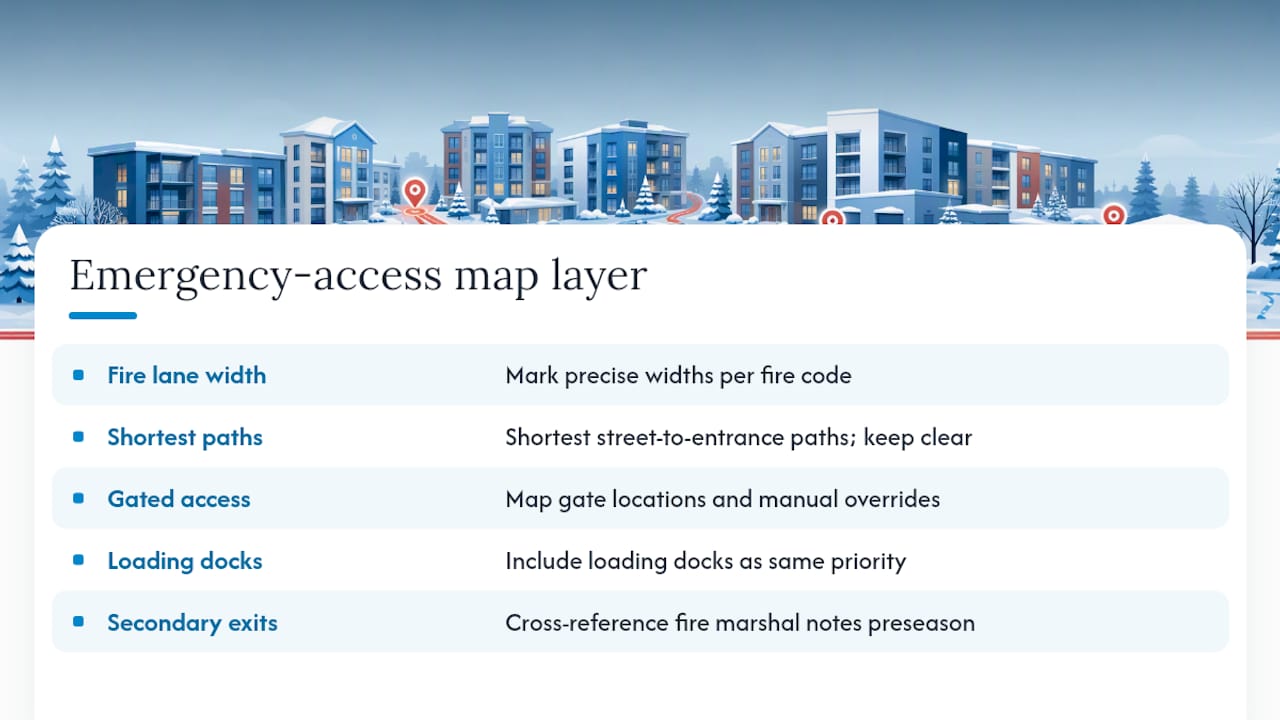
Loading docks and secondary building exits used for emergency evacuation belong on the same priority tier as the front entrance, even though they see less daily foot traffic. A site map that treats them as afterthoughts creates a blind spot that shows up exactly when it matters most. Cross-reference these routes with your building’s fire marshal walkthrough notes if one exists, since local fire officials sometimes flag access concerns that never make it into a standard property survey. Building this layer into the map once, during the preseason walk-through, costs far less than discovering the gap during an actual emergency.
Coordinating With Local Authorities on Snow Removal Compliance
Denver and its surrounding municipalities enforce sidewalk clearing ordinances with specific timelines, and a site map built without checking those rules risks putting a property out of compliance even when the contractor shows up on schedule.
Confirm your municipality’s clearing deadline after a snow event ends, since this window is what your SLA’s response time needs to beat, not the other way around. Some jurisdictions also regulate where cleared snow can be piled, restricting stacking near storm drains or public rights-of-way, which is another reason the map’s stacking zones need to reflect actual local rules rather than just available space. HOAs in particular should check whether their governing documents already specify clearing standards that predate the current contract, since those internal rules can be stricter than city ordinances.
Keep a copy of the relevant municipal code or ordinance summary alongside the map itself, so if a compliance question comes up mid-season, the answer is one document away instead of a call to the city. Contractors familiar with the Denver Metro area typically already track these deadlines, but the property manager or HOA board carries the ultimate liability for compliance, which makes it worth confirming rather than assuming.
Communication Protocols for Updates During Snow Events
A site map is only as good as the communication loop that surrounds it once snow actually starts falling, and this is the piece most contracts leave vague.
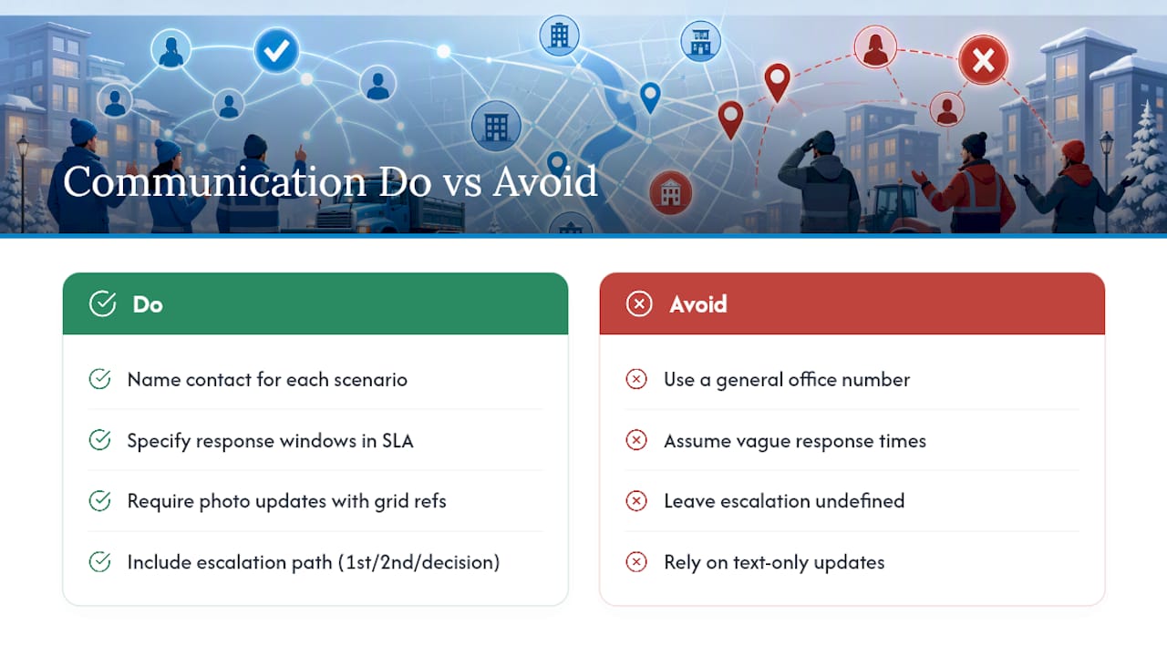
Define, in writing, who calls whom when conditions change mid-storm. A tenant reports a blocked fire exit, a board member wants a specific lot prioritized differently that day, or a contractor needs to flag that a stacking zone is full three days into a multi-storm stretch. Each of these needs a named point of contact on both sides, not a general office number that may or may not be staffed during a blizzard.
Set expectations for response windows separately from clearing windows. A property manager reporting an issue at 6 a.m. needs to know whether to expect acknowledgment within 30 minutes or by end of day, and that answer should be spelled out in the SLA rather than assumed. Photo updates tied to the map’s grid references work well here, since a quick image showing a specific zone’s status communicates more than a text message claiming “we’re on it.”
Multi-event storms, common in the Denver Metro area, put extra strain on this loop because priorities shift as stacking zones fill and access needs change day to day. Building a simple escalation path, first call, second call, decision-maker, into the SLA keeps a minor scheduling conflict from turning into a service dispute once the snow finally stops.
Publisher Perspective: How Denver Snow Removal Uses Site Maps in Operations
After more than 44 years clearing lots and sidewalks across the Denver Metro area, one pattern holds: the properties with the fewest complaints are the ones with a real map, not a verbal understanding. Running 24/7 during active storms means crews rotate, and a driver who has never seen a property before needs that map and its stakes to work correctly on the first pass. Denver Snow Removal builds preseason walk-throughs, staking, and event documentation into every contract for exactly that reason. A map drawn once and forgotten helps nobody by February.
— Jesse
Get Your Property’s Site Map Built Before the First Storm
A direct route to a working, SLA-ready site map is a better alternative to a verbal agreement you hope holds up in a dispute. A free estimate typically includes a preseason site walk-through to mark boundaries, priority tiers, stacking zones, and staging areas, then attaches that map to the service agreement as the governing scope document.
Contracts can include staking, event documentation with time-stamped photos, and coordinated hauling once agreed triggers are hit, so nothing gets left to memory once the snow starts falling. If your property needs commercial snow removal service covering sidewalks and loading docks, request your estimate now and get the walk-through scheduled before the first storm of the season.
Standards and Templates Worth Bookmarking
For the underlying standards behind everything above, start with SIMA’s site engineering planning checklist and SIMA’s staking best practices. For property-specific planning help, Denver Snow Removal’s contract structuring guide and commercial property guide cover the operational side in more depth. For sites managing roof drainage feeding into ground-level meltwater paths, flat roof drainage guidance is a useful companion resource.
Sources
- SIMA standards
- SIMA site engineering planning checklist
- Commercial snow & ice control: site mapping and slip/fall documentation
FAQ
What Is a Snow Removal Site Map?
It is a property-specific plan showing boundaries, priority-tier clearing areas, stacking and staging zones, and critical infrastructure, attached to the service contract as the governing scope document.
Does a Site Map Need to Be Attached to the Contract?
Yes. SIMA’s procurement guidance recommends embedding the map in the SLA specifically so it can serve as objective proof during billing or scope disputes.
How Often Should the Map Be Updated?
Re-verify it after major storms, check stakes at midseason, and run a full update before each new season since drainage patterns and tenant needs shift year to year.
Who Should Attend the Preseason Walk-Through?
The property manager or an HOA board liaison, plus the contractor’s operations lead, so the map reflects real site conditions rather than an outdated floor plan.
Can Denver Snow Removal Create the Site Map for My Property?
Yes. Preseason walk-throughs and free estimate processes can build the map, stake the property, and attach the finished document to service agreements.