
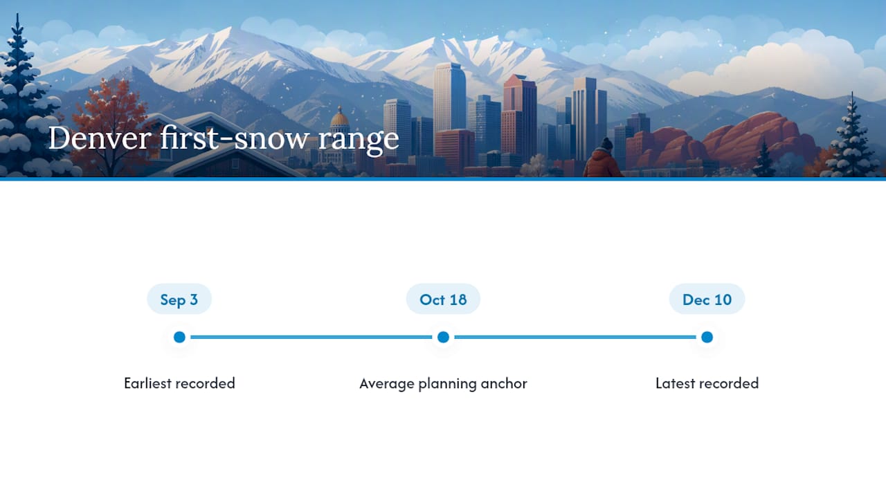
Denver’s average first measurable snowfall lands on October 18, based on National Weather Service climate records dating back to 1882. Measurable snowfall means an accumulation of 0.1 inches or more, the official threshold used to distinguish a real snow event from a light dusting that melts by lunch.
TL;DR:
- The earliest recorded first measurable snow in Denver was September 3, 1961, while the latest was December 10, 2021, a three-month difference.
- The average first snow date is October 18, based on data since 1882, but actual first snow timing varies widely year to year.
- El Niño and La Niña patterns significantly influence storm tracks, causing the first snow to arrive anywhere from early September to mid December.
- Denver’s official snowfall records may be affected by site changes and localized differences, making individual snow events harder to predict accurately.
- Homeowners should lock in snow removal contracts early in October, well before the average first snow date, to avoid last-minute shortages and higher costs.
Table of Contents
- What Is Denver’s Average First Snow Date, and What Counts as “Measurable”?
- How Early or Late Has Denver’s First Snow Actually Arrived?
- Why Does Denver’s First Snow Date Shift So Much From Year to Year?
- How Much Snow Does Denver Get in a Typical Winter?
- When Should You Lock In Snow Removal Plans for the Season?
- What a Denver Snow Removal Crew Sees Every Fall
- Averages Guide You, but They Don’t Protect You
- Ready for Winter? Here’s What to Do Before the First Flake Falls
- Sources
- FAQ
What Is Denver’s Average First Snow Date, and What Counts as “Measurable”?
If you own property in Denver, October 18 is the date to circle on your calendar every year, but it deserves context. The National Weather Service’s climate data for Denver stretches back to 1882, making it one of the longer continuous weather records in the region. That length matters because it smooths out the wild swings any single season can produce.
The 0.1 inch threshold isn’t arbitrary. Denver forecasters use it consistently to define what actually counts as “snow” in the official record, according to NWS fall and winter statistics. A few flurries that coat the grass but never touch the pavement don’t make the cut. This is why you might remember seeing snowflakes in late September some year, yet the official record shows the first measurable snow arriving weeks later. Your eyes weren’t wrong. The threshold just wasn’t met.
October 18 is an average, not a forecast. It’s built from more than 140 years of data, and individual years swing wildly in both directions, which is exactly what the next section breaks down.
How Early or Late Has Denver’s First Snow Actually Arrived?
The gap between Denver’s earliest and latest first-snow dates on record is enormous, and that spread is the real story behind the October 18 average. On the early end, Denver has seen measurable snow as early as September 3, 1961. On the late end, the city once went without any measurable snow until December 10, 2021, when just 0.3 inches fell, according to NWS records tracking Denver’s first-snow dates. That’s a difference of more than three months between the two extremes.
Late arrivals aren’t as rare as you’d think. November 21, 1934, and November 19, 1931, both produced 1.0 inch as the season’s first measurable snow, showing that a mid-to-late November start has happened more than once in the historical record.
| Rank | Date | Snowfall Amount | Type |
|---|---|---|---|
| 1 | September 3, 1961 | Measurable (early record) | Earliest first snow |
| 2 | December 10, 2021 | 0.3 in | Latest first snow |
| 3 | November 21, 1934 | 1.0 in | Notable late start |
| 4 | November 19, 1931 | 1.0 in | Notable late start |
These aren’t cherry-picked outliers from some obscure corner of the record. They’re the bookends of a dataset going back to 1882, and they tell you something practical: if you’re planning around “mid-October,” you’re planning around an average that has been wrong by weeks, sometimes months, in either direction.
Why Does Denver’s First Snow Date Shift So Much From Year to Year?
Two forces drive most of the year-to-year swing: large-scale climate patterns and where storm tracks decide to aim themselves that season.
El Niño and La Niña cycles shift the jet stream and change how often storm systems drop into Colorado during early fall, according to NOAA guidance on El Niño and La Niña impacts. A La Niña pattern tends to push storm tracks north, which can delay the first Front Range snow. An El Niño pattern often does the opposite, opening the door for earlier moisture.
Recent seasons illustrate the point well. The 2021 season pushed all the way to December before Denver recorded its first measurable snow, an outcome local weather teams flagged as a major departure from the Oct. 18 average, per 9NEWS coverage tracking Denver’s seasonal first-snow timing. Other recent years have landed closer to the historical norm, underscoring how much the pattern can vary even within a few seasons of each other.
There’s also a measurement wrinkle worth knowing about. Denver’s official observation point moved to Denver International Airport in 2008, shifting the recording location away from the older downtown and Stapleton-era sites. Differences between airport readings and urban or suburban cooperative observer (COOP) stations mean a single official reading can miss a localized snow event happening a few miles away, according to the NWS seasonal snowfall records. A yard in Wheat Ridge can pick up measurable snow on a day DIA records nothing.
- El Niño and La Niña shift storm tracks north or south, changing how often fall systems reach Denver.
- Site relocations, especially the 2008 move to DIA, complicate direct comparisons between older and newer records.
- Single daily observations at one official site can miss localized snow that falls just outside that station’s footprint.
- Records since 1882 range from an early September first snow to a December first snow, a spread of over three months.
The range is the real headline here. Records since 1882 show Denver’s first measurable snow has fallen anywhere from early September to mid December, which makes any single year’s timing a coin flip against the average rather than a safe bet.
How Much Snow Does Denver Get in a Typical Winter?
The October 18 average first-snow date sits inside a much larger seasonal picture, and the numbers here need a little unpacking because two “official” figures don’t match.
Denver’s long-term average seasonal snowfall, calculated across the full 1882 to present record, comes out to about 56.6 inches. But the National Centers for Environmental Information’s more recent 1991 to 2020 climate normal puts the figure closer to 49 inches, according to the NWS seasonal snowfall data. The gap isn’t a contradiction. It reflects different observation periods, station moves, and methodology changes over more than a century of record keeping. The 30-year normal is generally the more useful number for near-term planning since it reflects current conditions rather than a blend of eras.
Location inside the metro matters just as much as the calendar. The Colorado Climate Center notes that the Front Range urban corridor, where most of Denver’s population lives, typically sees its first snow in mid-to-late October. Foothills communities and higher elevations west of the city tend to see snow earlier and heavier, sometimes weeks ahead of the valley floor.
What does this mean in practice for a Denver property owner?
- Expect several separate snow events between October and April, not one long continuous winter.
- Properties closer to the foothills should plan for an earlier start to the season than properties near DIA or in the eastern suburbs.
- A “normal” winter still means multiple driveway and sidewalk clearing needs before Thanksgiving in most years.
When Should You Lock In Snow Removal Plans for the Season?
Given that the average first snow lands October 18, the smart window to finalize a snow removal plan is early October, before demand spikes and before that first storm catches you unprepared. Waiting until snow is already falling puts you behind property owners who secured a contract weeks earlier.
- By early October: Request estimates and compare seasonal contract terms with local providers.
- By mid-October: Finalize your service agreement, confirm response windows, and lock in pricing before the average first-snow date arrives.
- Before the first storm: Stock ice melt, check your snow shovels and blowers, and confirm an emergency contact list for any provider you’ve hired.
- All season: Recheck your plan after any unusually early or unusually late start, since a shifted first snow often means a shifted rest of the season too.
If you’re figuring out your own checklist item by item, the seasonal snow preparation steps for homeowners and the month-by-month snowfall averages both break this down further. Weatherizing entry points matters here too. Sealing gaps around doors, something covered well in this guide to winterizing doors, keeps melting snow and cold air from turning your entryway into its own maintenance problem.
Pro Tip: Don’t treat October 18 as a fixed deadline. Pair the historical average with the NWS’s short-range forecasts and the Climate Prediction Center’s seasonal outlooks. The average tells you when to be ready. The forecast tells you when to actually act.
What a Denver Snow Removal Crew Sees Every Fall
Averages are clean numbers. Real Denver winters are not. In years when the first measurable snow arrives close to schedule, contract sign-ups spread out evenly through September and early October. In years like 2021, when nothing measurable fell until December, the calls that do come in tend to arrive all at once, in a rush, right when a provider’s schedule is already tightest.
A late start doesn’t mean a light winter. It often means the opposite: less warning, more urgency, and a compressed window where every property owner who delayed is calling at the same time. With 44 years of watching Denver seasons unfold, the pattern holds again and again: the properties that stay ahead of trouble are the ones that signed a plan before the first flake, not after.
Some snow removal companies keep crews on call 24/7 for exactly this reason. Averages are a planning tool. They are not a guarantee.
Averages Guide You, but They Don’t Protect You
Here’s what the record actually supports: October 18 is a useful planning anchor, but treating it as a promise is where most homeowners get burned. The spread between the earliest recorded first snow (September 3) and the latest (December 10) is wider than most people realize, and that gap is the whole point. An average built from more than 140 years of data absorbs a lot of noise. Any single year can, and regularly does, fall far outside it.
The conventional advice, “watch for snow in mid-October,” isn’t wrong, but it’s incomplete. It skips the part where storm tracks driven by El Niño and La Niña patterns can push the first snow a month earlier or two months later than the norm. It also glosses over the fact that a single official observation site, even one as reliable as DIA’s, can miss what’s actually happening in your specific neighborhood.
My take: prioritize the contract date over the snow date. Lock in service before mid-October regardless of what the sky looks like that week. The average tells you the odds. It doesn’t tell you your year.
— Jesse
Ready for Winter? Here’s What to Do Before the First Flake Falls
Some local snow removal providers offer alternatives to scrambling for a contractor mid-storm. Instead of calling around while snow is already piling up, you can lock in coverage before the season’s first measurable snowfall, preferably with a provider experienced in Denver winters.
Services often cover a range property owners and managers need: seasonal contracts for residential driveways and walkways, emergency plowing when a surprise storm hits, and commercial sidewalk and parking lot clearing for businesses and HOAs. Given that Denver’s average first snow lands October 18, early October is a recommended time to request estimates and get seasonal contracts in place before demand tightens up.
If you manage a commercial property, the commercial snow removal service for sidewalks and loading docks covers what businesses need most. For homeowners ready to lock in a plan now, start with a free estimate on our snow plowing Denver services page and get ahead of the season before the first flake falls.
Sources
- Seasonal snowfall and normals (National Weather Service – BOU)
- First snows in Colorado (Colorado Climate Center blog)
- When will Denver get its first snow? (9NEWS local reporting)
FAQ
What Is the Average First Snow in Denver?
Denver’s average first measurable snowfall date is October 18, based on National Weather Service climate records dating back to 1882. Measurable snowfall is defined as 0.1 inches or more.
What Was Denver’s Biggest First-Snow Delay Ever Recorded?
The latest first measurable snowfall on record occurred December 10, 2021, when just 0.3 inches fell, according to NWS records. Other notably late starts include November 21, 1934, and November 19, 1931.
What Month Does Denver Start Getting Snow?
Most years, Denver’s first measurable snow falls in mid-to-late October, matching the average date of October 18. The Front Range urban corridor typically sees snow later than the nearby foothills, which often get their first snow weeks earlier.
How Early Has It Started Snowing in Denver?
The earliest recorded first measurable snowfall in Denver’s history was September 3, 1961. That remains the earliest date on record dating back to 1882.
Is Denver’s Total Seasonal Snowfall Higher Than the First-Snow Date Suggests?
Denver’s long-term average seasonal snowfall is about 56.6 inches, while the more recent 1991 to 2020 climate normal is closer to 49 inches. The difference reflects changes in observation methods and station locations over time, not a single contradictory figure.
Recommended
- Denver Average Snowfall by Month: What to Expect
- Seasonal Snow Preparation Steps for Homeowners
- Planning for Snow Plowing in Starting early to get you the best rates, instead of waiting to the winter comes when the rates will be at their highest. Planning early would be the perfect choice for your commercial property or commercial parking lots. Give us a call here at Denver snow removal and snowplowing and we will get back with you as soon as possible thank you It was a call here at Denver snow removal and snowplowing and we will get back with you as soon as possible thank you.Denver – Snow Removal Denver 303-591-2089
- The Ultimate Winter Storm Preparedness Guide for Denver Businesses